


The Second Front, Part IIa: PRC Micro-Occupation in The Philippines

Editor’s note: This article is the first half of a two-part feature on The Second Front. Part IIb is forthcoming. Catch up with Part I—Armed Forces of the Philippines: Community Home Defense Operations (CHDO) Development—here. _________________________________________________________________________________________________________________
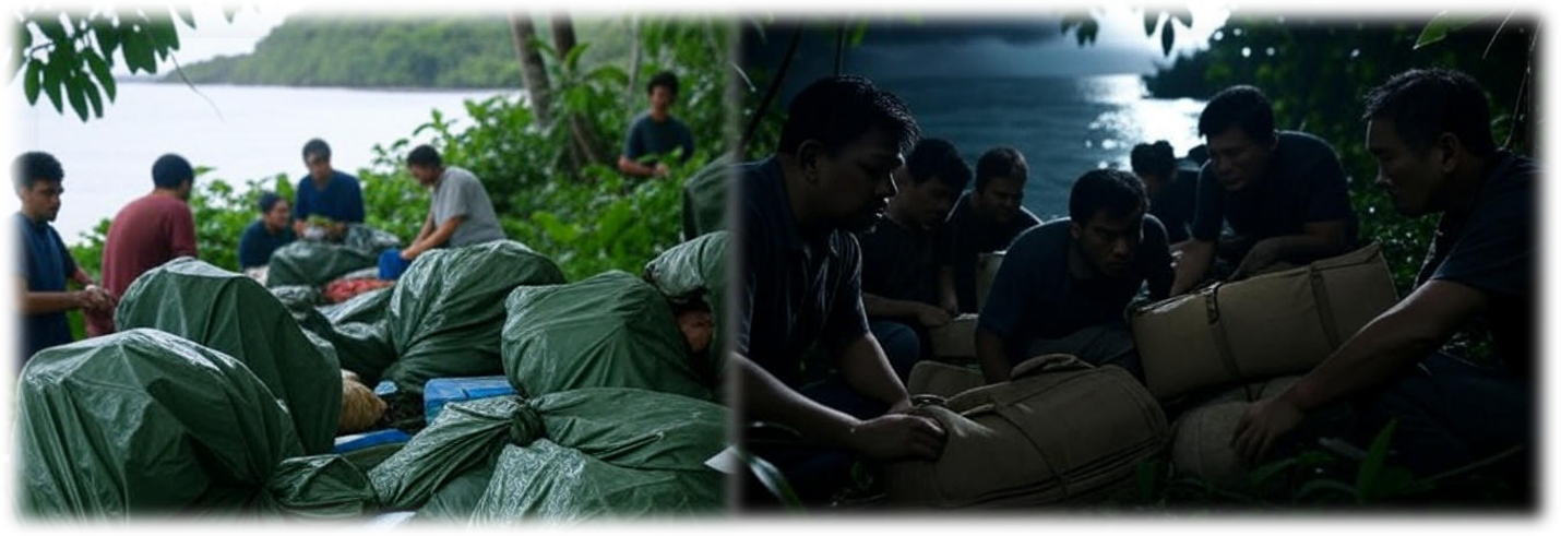
“If we carry out the cabbage strategy, you will not be able to send food and drinking water onto the islands. Without the supply for one or two weeks, the troopers stationed there will leave the islands on their own. Once they have left, they will never be able to come back.”
— Major General Zhang Zhaozhong, People’s Liberation Army, May 2013
“If sliced thinly enough, no one action will be dramatic enough to justify starting a war. How will a policymaker in Washington justify drawing a red line in front of a CNOOC oil rig anchoring inside Vietnam’s EEZ, or a Chinese frigate chasing off a Philippines survey ship over Reed Bank, or a Chinese infantry platoon appearing on a pile of rocks near the Spratly Islands?”
— Foreign Policy, “Salami Slicing in the South China Sea,” 2012
From Gray-Zone to Micro-Occupation
President Ferdinand Marcos Jr. observed in August 2025 that the Philippines cannot avoid involvement in a Taiwan crisis because of its location. While Washington’s strategic planning focuses on the Taiwan Strait as the primary theater, the Philippines serves as a critical secondary front that could ultimately determine whether Beijing achieves its strategic objectives or if Taiwan maintains its freedom. The People’s Republic of China’s (PRC) gray-zone activities in the West Philippine Sea are increasingly merging into the occupation of features in contested waters. This article proposes a framework for understanding and prioritizing vulnerabilities to the PRC’s efforts to alter the facts on the ground through infrastructure development and coercion, thereby creating a shared operational picture similar to Taiwan’s identification of its fourteen “red beaches” as priority invasion sites.
Micro-occupation, or the seizure and occupation of extraterritorial key terrain for purposes other than invasion of a state’s sovereign territory to effect regime change, represents a fundamental evolution in territorial aggression. The occupation of limited terrain is calibrated to remain below traditional thresholds of war while achieving strategic objectives. Unlike the comprehensive territorial conquests of the colonial era or World War II, modern actors exploit the constraints of nuclear deterrence, economic interdependence, and international law to secure limited but critical extraterritorial gains. For the Philippines (with its 7,641 islands totaling a land mass equivalent to Arizona but spread over 1,150 miles from north to south), this threat poses unique challenges that demand ruthless prioritization within the nation’s severe resource constraints. The archipelago’s geographic position makes the Philippines not merely a supporting player but potentially the decisive terrain in any nation’s strategy regarding Taiwan.
Micro-Occupation in the Philippine Context
Micro-occupation in the Philippines involves the calculated seizure of islands, maritime features within the Philippines’ exclusive economic zones, or critical infrastructure that advances PRC strategic objectives while avoiding casus belli. These operations employ what Chinese strategists call “combination punches:” synchronized military, paramilitary, economic, and information operations designed to present a fait accompli before effective responses can be mounted. This doctrine was applied during the PRC’s successful seizure of Mischief Reef in 1995 and Scarborough Shoal in 2012, where incremental actions below the threshold of war altered the facts on the ground to include PRC personnel and facilities on features not claimable under the United Nations Convention on the Law of the Sea. These episodes triggered a Philippine military response, but one that was so limited it failed to alter the outcome.
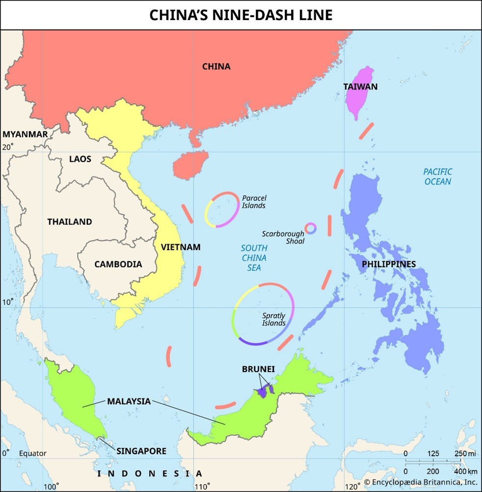
Figure 1. The South China Sea and the PRC’s Extraterritorial Claims
No state can effectively defend over seven thousand islands simultaneously, particularly when facing an adversary with the People’s Liberation Army’s growing power projection capabilities. The Armed Forces of the Philippines’ (AFP) limited air and sealift capacity prevents immediate response to threats in Batanes or Palawan. This geographic reality forces Philippine defense planners to make hard choices about which territories to defend, which must prepare for resistance after occupation, and which may need to be temporarily ceded to preserve forces for decisive battles.
The Enhanced Defense Cooperation Agreement (EDCA) sites strengthen deterrence as a representative of the US partnership. However, these sites are also high-value targets that the PRC might seek to neutralize preemptively in the event of a conflict over Taiwan. These locations, from Naval Base Camilo Osias in northern Cagayan to Balabac Island in southern Palawan, represent both strategic assets and potential vulnerabilities that shape PRC planning. These are not formal US bases but Philippine facilities with American access rights. PRC planners must assess whether targeting of these sites would trigger the US-Philippines Mutual Defense Treaty. Beijing likely calculates that limited, deniable actions against EDCA facilities — such as cyberattacks, sabotage, or temporary seizure — might fall into a gray area that delays or prevents an American military response.
Tier 1 Red Zones: Ongoing Crisis in the West Philippine Sea
The West Philippine Sea features are categorized as red zones in our framework and are the most vulnerable to PRC occupation (depicted in Figure 1). The PRC is encroaching on these maritime features through escalating gray-zone tactics and outright seizure. The PRC has constructed artificial islands by dredging sand from the sea floor, which are patrolled by persistent maritime militia, providing platforms to project power and escalate conflict rapidly.
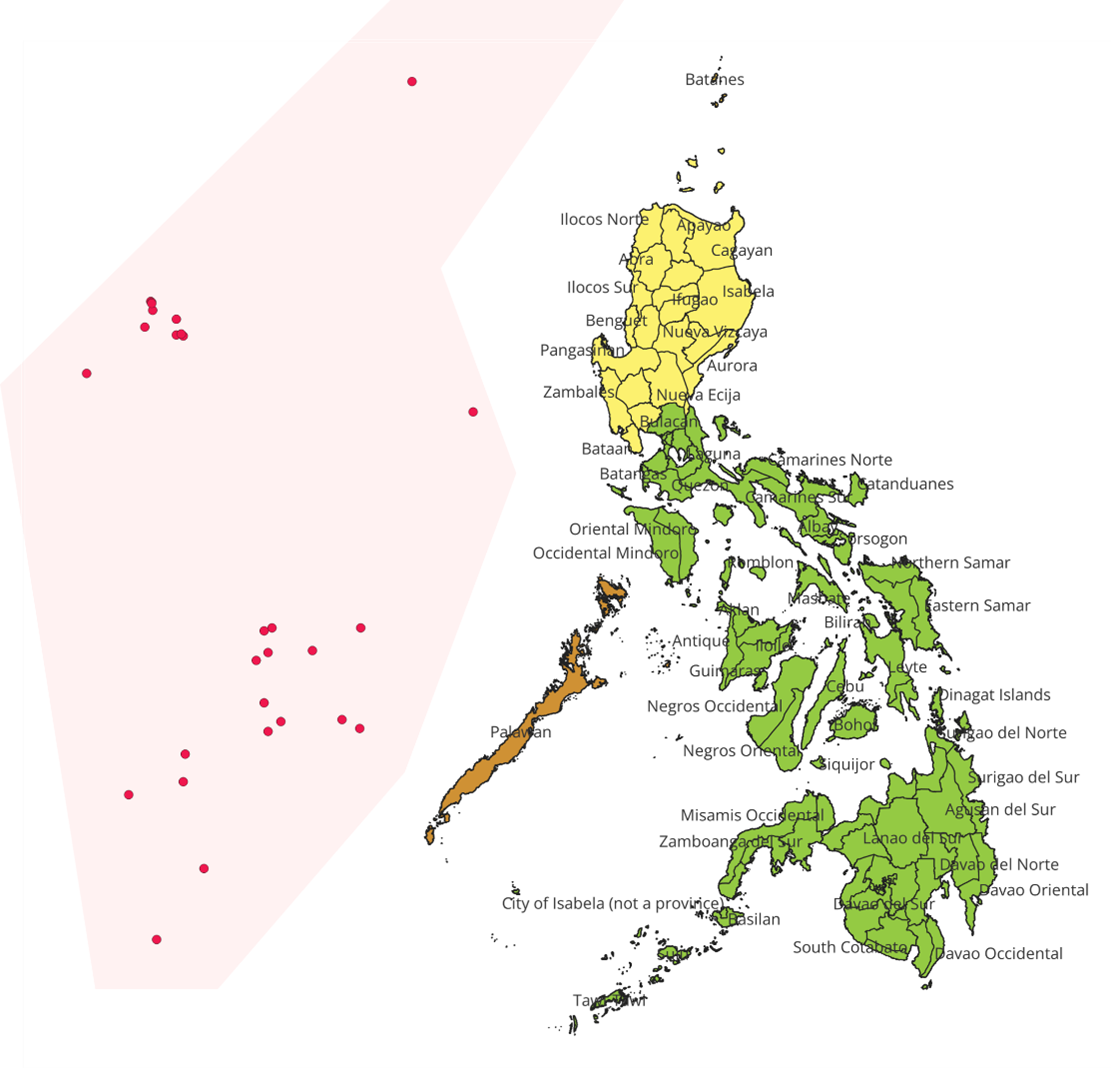
Figure 2. The Philippine Islands depicting Red, Yellow, Gold, and Green Threatened Zones (image created by the authors using QGIS)
Second, the Thomas Shoal provides a precarious flashpoint. The rusting hull of BRP Sierra Madre, with its rotating Marine garrison, represents a Philippine claim to sovereignty that Beijing desperately seeks to eliminate. PRC Coast Guard vessels regularly interfere with resupply missions using water cannons, dangerous maneuvers resulting in injury to Philippine sailors, and physical barriers. The escalation from blockade to coercing the withdrawal of the Philippine Marines or forcible ejection requires only a political decision in Beijing, not additional military capability. The isolation of this feature makes it virtually indefensible against a determined PRC seizure.
The PRC occupation of Second Thomas Shoal would likely follow the playbook applied to nearby features. The PRC’s maritime militia will increase the frequency and violence of their interference with fisherfolk and civilian watercraft, escalating from water cannons to ramming, beating civilians, and injuring or killing Philippine personnel. They will declare an environmental zone around the shoal, limiting access by fisherfolk from other nations. The militia and Coast Guard would prevent access to the area under the guise of enforcing the safety zone. After denying Philippine presence, the PRC will dredge the sea floor to build the feature’s height and establish a facility with prefabricated structures to conduct environmental monitoring. This process would be completed before the Philippines or its allies could respond, leaving no recourse to reverse the seizure without military force. Conversely, successful defense of Second Thomas Shoal, through innovative resupply methods or international pressure, would demonstrate resolve and potentially deter further PRC aggression.
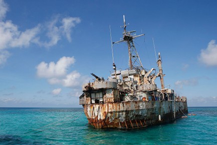
Figure 3. The Sierra Madre at Second Thomas Shoal
Scarborough Shoal presents a different but equally urgent challenge. Under de facto PRC control since 2012, this feature sits only 124 nautical miles from Luzon, within both the Philippines’ Exclusive Economic Zone (EEZ) and missile range to threaten AFP forces at Subic Bay and Clark Air Force Base. PLA militarization would create an anti-access bubble neutralizing Northern Luzon’s strategic value in a Taiwan contingency. PRC maritime militia vessels maintain a constant presence, preventing Filipino fishermen from accessing traditional grounds while avoiding actions triggering US treaty obligations.
As with the PRC’s transformation of the Spratly Islands from fishing grounds to military bases, the PRC will claim that initial construction will support environmental protection, followed by basic infrastructure that requires defensive weapons to protect civilian facilities. A dual-use installation would follow, protected by radar systems, surface-to-air missiles, and anti-ship cruise missiles. From Scarborough, PRC forces could effectively control air and sea approaches to Manila, monitor or jam communications across Northern Luzon, and threaten any US forces operating from Philippine bases. The strategic impact would be equivalent to placing a PRC military base just off California’s Catalina Island.
The persistent presence of PRC survey vessels indicates a detailed mapping of the shoal’s geology for construction planning purposes. The increasing size and capability of PRC ships around Scarborough, including the deployment of the 12,000-ton CCG 5901, the world’s largest coast guard vessel, demonstrate Beijing’s commitment to maintaining control of this feature. The construction of a “maritime rescue center” on nearby Woody Island serves as a template for dual-use facilities that evolve into military installations.
Sabina Shoal, 75 nautical miles from Palawan, has emerged as the newest arena for PRC expansionism. The increasing presence of the PRC Coast Guard and maritime militia signals Beijing’s intent to replicate its playbook in the Scarborough Shoal. Without a permanent Philippine presence, Sabina remains vulnerable to the “cabbage strategy,” which involves layers of fishing vessels, maritime militia, the Coast Guard, and eventually, naval forces, establishing new facts on the ground.
The use of militia swarms backed by military forces mirrors the PRC’s use of civilians with military forces while establishing “facts on the mountains” as it seeks to alter its border with India. The addition of civilians to patrols complicates response, as military action against ostensible civilians risks international opprobrium, and allows the PRC to claim that its response was defensive even when conflict occurs on the wrong side of a border.
Tier 2 Orange Zones: Batanes and the Taiwan Proximity Challenge
Batanes Province, designated here as an orange zone, represents the second priority for occupation. These islands’ proximity to Taiwan – only 190 kilometers from Basco to Kaohsiung – makes them invaluable for PRC air defense, intelligence gathering, and channel control in any cross-strait operation. Unlike features in the West Philippine Sea, Batanes is an inhabited archipelago where occupation would require managing civilian populations with their own history and culture.
Mavulis Island, the Philippines’ northernmost point at 141 kilometers from Taiwan’s southern coast, could be seized by PLA special operations forces within hours. Its strategic value for positioning radar systems, surface-to-air missiles, or anti-ship cruise missiles to control the Bashi Channel makes it a priority target. The island’s isolation and lack of permanent military presence mean occupation could be accomplished before Manila could mount a meaningful response.
Itbayat Island presents different challenges for the PRC because of its approximately 3,000 Filipino inhabitants. Occupation would require either population control or forced evacuation, generating international attention and domestic outrage. However, the island’s single airstrip and limited harbor facilities make it valuable for forward PLA deployment. A minimal military presence, consisting of occasional Coast Guard patrols without a permanent AFP garrison, leaves Itbayat vulnerable to a rapid heliborne or amphibious seizure.
Batan Island, which hosts the provincial capital of Basco with 8,000 residents, represents the most complex target in Batanes. With functioning civilian infrastructure and the best transportation links to Luzon, Batan would provide a ready-made forward operating base. The Basco weather station’s regional meteorological data, combined with the airport’s capability to handle military transport aircraft, makes this island particularly valuable. Yet occupation would require substantial forces for population control and defense against counterattacks. The psychological impact of occupying a provincial capital would likely resonate throughout the Philippines, potentially triggering either fierce resistance or a more accommodating response.
The human dimension of Batanes adds complexity to the occupation. The Ivatan people, with their distinct culture and strong community bonds, have historically shown remarkable resilience in the face of natural disasters. This social cohesion could translate into effective resistance networks or, conversely, render the population vulnerable to collective coercion. PRC information operations would likely emphasize “protecting” the Ivatan from becoming collateral damage in the US-PRC confrontation, exploiting the community’s isolation from mainstream Filipino society.
Should PRC military planners deem the occupation of the Batanes Islands as necessary to their forcible seizure of Taiwan, operations would likely include electronic warfare and cyber operations to isolate the islands from Manila, as information operations portray occupation as temporary and intended to protect civilians. The initial insertion force would likely comprise PLA special operations forces such as the Sea Dragons, arriving via civilian vessels or aircraft to maintain ambiguity, followed by regular marines once control is established. Historical precedent from Russia’s operation in Crimea suggests the effectiveness of “little green men,” unmarked special forces that provide a deniable presence until a fait accompli is achieved.
Tier 3 Yellow Zones: Northern Luzon’s EDCA Vulnerabilities
EDCA sites in Northern Luzon, classified here as a yellow zone, face an elevated risk of PRC interference, though complete occupation remains less likely than sabotage or temporary neutralization. The importance of these facilities for US force projection makes them inevitable targets, but their connection to American defense treaty obligations complicates PRC decision-making.
Naval Base Camilo Osias is the northernmost EDCA naval facility, positioned to support operations in the Luzon Strait. Its isolated location and limited ground defense make it vulnerable to special operations raids or standoff strikes. Rather than occupation, PRC forces may attempt cyberattacks on command systems, physical sabotage of fuel and ammunition storage, or precision strikes on critical infrastructure. The base’s dependence on a single access road makes it vulnerable to infiltration by special operations forces from the sea, a threat that requires maritime patrol capabilities and underwater sensors.
Lal-lo Airport presents a softer target as a civilian facility that is also designated for military use. With minimal security in a populated area, this airport could be neutralized through various means short of occupation. Information operations focused on stirring local opposition, cyberattacks on air traffic control, or covert runway sabotage could achieve PRC objectives without the need for troops on the ground. The dual civilian-military use creates unique challenges; PRC agents could efficiently conduct reconnaissance under civilian cover, mapping defenses and identifying vulnerabilities for future exploitation.
Camp Melchor Dela Cruz faces different vulnerabilities as a large Army training base. Its extensive perimeter challenges comprehensive defense, while its inland location reduces immediate operational value. Rather than an occupation, this facility would likely face information warfare and cyber operations against base systems. The large training areas provide concealment opportunities for infiltrators, necessitating persistent surveillance of remote sections and regular sweeps for cached equipment or weapons.
In addition to physical security, these facilities require protection against sophisticated influence operations targeting both military personnel and surrounding communities. The proximity of EDCA sites to local populations creates opportunities for PRC to mobilize opposition through economic inducements, environmental concerns, or anti-American nationalism. Protecting against these threats requires comprehensive counter-intelligence programs, financial security monitoring of personnel with access to sensitive information, and proactive community engagement to build resilience against PRC influence operations.
The PRC operations in yellow zones would emphasize deniable and reversible actions, achieving military objectives while avoiding explicit acts of war. Cyber operations, information warfare, economic coercion, and limited special operations can effectively neutralize facilities without requiring the resources and risks associated with occupation.
Tier 4 Gold Zones: Palawan and Strategic Depth
Palawan and its associated features, designated as gold zones, represent lower-probability but high-impact micro-occupation targets. The island’s 650-kilometer length creates multiple potential objectives, but its strategic importance ensures a stronger Philippine defense and increases the likelihood of US intervention.
Forces at Balabac Island, located at Palawan’s southern tip, could project power into the Balabac Strait between the Sulu Sea and the West Philippine Sea. Its sparse population and limited infrastructure make it vulnerable, but distance from Taiwan and limited immediate utility reduce its priority for PRC planners. Occupation here would support broader control of the West Philippine Sea, rather than supporting conflict with Taiwan, as control of these features would protect the flanks during the PRC’s consolidation of gains.
Antonio Bautista Air Base would face standoff strikes rather than occupation attempts. Its value for air operations makes it a likely target for ballistic and cruise missiles, but physical occupation would require substantial forces that could be better employed elsewhere. The base’s integration with Puerto Princesa and the significant presence of Philippine forces make occupation costly and complex.
The Kalayaan Island Group, particularly Pag-asa Island, already faces persistent pressure from the PRC through gray-zone activities. With existing civilian and military presence, these features represent extensions of current disputes rather than new micro-occupation scenarios. PRC control would likely result in the Spratly Islands’ domination, but it would likely occur through gradual escalation rather than a sudden seizure. The 200 Filipino civilians on Pag-asa will likely face gray zone operations, as militias surround the island with vessels, interfere with civilian watercraft, and constrain the Philippine’ freedom of movement until residents are coerced to leave.
The Sibutu Passage, Balabac Straight, and Mindoro Strait are critical maritime chokepoints beyond the major islands that gold zone operations would also target. Gold zone operations would also target critical maritime chokepoints beyond the major islands. These narrow waterways are vital for both commercial shipping and potential military operations. PRC special operations forces or maritime militia could establish a “temporary” presence on small, uninhabited islands, controlling these passages, and justify their actions as anti-piracy operations or maritime safety measures. Once established, these positions would be difficult to dislodge without appearing as an aggressor, particularly if the PRC maintains the fiction of civilian purpose. The pattern from the West Philippine Sea suggests that “temporary” structures have a way of becoming permanent realities, protected by successive layers of legal arguments, information warfare, and eventually military force.
Continuation
Part IIa of this series summarized the PRC’s “salami-slicing” of features in the West Philippine Sea. It outlined a framework for planners to prioritize the development of deterrence capabilities and resilience networks, as well as to establish conditions for a robust Philippine resistance in areas where the AFP may not be able to defend during a significant conflict. Red zones, the contested features in the West Philippine Sea, represent areas under immediate threat from PRC gray zone operations and will require unconventional intervention strategies. Orange zones represent islands strategically crucial to the PRC’s seizure of Taiwan and during its occupation. These features are remote and challenging for the AFP to defend. Yellow zones describe terrain that the PRC may invade and occupy to deny its use to nations attempting to assist Taiwan. These areas will likely face both lethal and non-lethal fires. Gold zones indicate island features that are important for controlling the West Philippine Sea. These areas are strategically important but may be follow-on targets to prime objectives.
Part IIb will describe the green zones and likely PRC threats in these areas, regions unlikely to be occupied but likely to face non-lethal fires, such as misinformation, system disruption, and population resource control measures, which aim to support occupation in northern territories. The control of key Philippine territories could enable or prevent PRC power projection, determine the effectiveness of any blockade, and shape the strategic choices available to all parties.