Megacities and Dense Urban Environments: Obstacle or Opportunity?
Dawn A. Morrison and Colin D. Wood
Introduction
The United Nations (UN) projects that by 2030 there will be more than 41 megacities, with the majority of them located in Africa and Asia. These 41 cities alone will house approximately 9% of the world’s population, as rural life declines.[i] Approximately 54% of the world’s people are now urban residents, with 66% expected to be urban by 2050.[ii] More alarming, the number of people worldwide living in urban slums has increased by 33% since 1990.[iii] As rural to urban migration continues to increase, experts expect more frequent requirements for the U.S. military to be involved in responding to conflicts and disasters in densely populated urban environments. As more of the world population resides in littoral cities, natural disasters such as hurricanes, floods, health epidemics, and resource scarcity could pose significant challenges for military intervention. “While the U.S. military continues to protect U.S. national security interests across the globe, it must focus on protecting those interests where they are in most jeopardy. The greatest potential threats to those interests lie in Asia and the Middle East, and the U.S. Army’s role extends to both.”[iv] Of the 41 projected megacities, 25 are located in the Asia-Pacific and Middle East regions. Doctrine further recognizes the potential for urban areas to become redoubts for enemy forces and acknowledges that “joint operations will require land forces capable of operating in congested and restricted urban terrain,”[v] thus indicating U.S. doctrinal intent to operate within megacities and dense urban environments. In short, megacities and dense urban environments are firmly on the horizon as likely and potential environments for future warfare and humanitarian engagements. Are we prepared?
Current military thinking tends to present the megacity and dense urban environment as challenging, intimidating, and as a source of anxiety for military commanders who contemplate its operational environment. While megacities and dense urban environments are challenging and complex, we argue that the unique characteristics of these environments offer many opportunities and leveraging points that future U.S. military forces can use to their advantage to conduct successful military operations. The first step toward this new paradigm requires a solid method for understanding the operational environment of megacities and dense urban areas. We believe this can be done by operationalizing the megacity framework proposed by the Chief of Staff of the Army's Strategic Studies Group.[vi] Not only does this framework allow megacities and dense urban environments to be understood as a system of systems akin to a living organism, it also categorizes the level of integration between the systems. Operationalizing this framework was accomplished in Morrison et.al. (2016)[vii]. Here we discuss how the resulting composite index (Table 1) that was generated may be helpful in understanding the operational environment of different megacities, including the challenges of operating in these environments. By examining these challenges, however, we discovered that the framework allowed us to re-conceptualize the megacity not solely as an impossible military challenge, but rather as a place of potential opportunity offering several leverage points advantageous to future forces if new technology, tactics, techniques, and procedures can be adopted. This paper presents a brief overview of the operationalized megacity framework and demonstrates how it may be used to better understand the future operational environment. We consider the challenges presented to the military by the megacity and dense urban environment under current military thinking. Lastly, we explore several ways in which the military might meet and overcome these challenges by leveraging the megacity environment to its advantage, and capitalizing on the opportunities afforded by the complex environment.
Defining the Area of Regard (Megacity and Dense Urban Environments)
The megacity concept has a common operating definition: an urban or metropolitan area with a population of 10 million people or more.[viii] Less well-defined is the concept of dense urban environments. There is currently no standardized, metric-based definition for what constitutes a dense urban environment or for determining the point at which an area switches from urban to dense urban. The U.S. Census Bureau defines the minimum threshold to be considered urban as an area with 50,000 or more people with a minimum threshold of 1000 people per square mile, but does not define anything beyond the dichotomy of urban/rural.[ix] The fields of urban planning and urban design often factor in floor area ratio (FAR) and dwelling units per area (DU/Area) along with population density, and then examine the persistence of these metrics over scale, ranging from block or developmental parcel upwards to neighborhood, then district to city or region.[x] Using these metrics, we can begin to understand dense urban environments as places where either all three metrics—FAR, DU/Area and Population—are high (e.g., high rise districts of Tokyo, London or New York), or where DU/Area and Population remain high while FAR decreases (e.g., favelas of Rio de Janeiro or the slums of Dhaka). Employing a combination of these metrics may help provide a more accurate determination of urban density as they normalize population by infrastructure capacity, thereby allowing us to better identify and measure dense urban environments for the purposes of planning and execution of military operations. These metrics enable planners to understand the spatial distribution of the density and whether it is stacked vertically (high FAR, DU/AREA and Population) or concentrated at ground level (low FAR, high DU/Area and Population).
SSG Megacity Framework
To better understand megacities and dense urban environments, we implemented the megacity framework presented by the SSG.[xi] The SSG megacity framework is based on five characteristics—Context, Scale, Density, Connectedness and Flow—which are used to determine the level of integrated systems—Highly Integrated, Moderately Integrated and Loosely Integrated—found in each megacity. Integration, in turn, is based on the level of formal versus informal systems, the quality of infrastructure, and how regulated is the flow capacity of goods, resources, people, and information. Morrison et. al. (2016) operationalized the SSG megacity framework by compiling a composite index for each of the U.N.’s projected 41 megacities (Table 1) based on an extensive data matrix assembled from open sources. Metrics collected in the data matrix were selected to cover the five characteristics above, and then cross-walked to address the integration areas of system types, infrastructure quality and regulated flow capacity. For example, data was collected on such topics as governance, rule of law, stability, quality of life, politics, airports, seaports, railroads, roads, economic growth and performance, communication, demographics and other associated human geography variables.[xii] Much of the data used to compile the index is drawn from regularly updated metrics so that the operationalized framework has the ability to remain current over time. We believe this index adequately represents the level of integrated systems for each megacity and allows opportunity to better understand both the positives and negatives of the megacity and dense urban environment in terms of military operations and how they will vary depending on the level of integration; for example, responding to a natural or man-made disaster in a highly versus loosely integrated megacity.
Morrison et al (2016) further connected the operationalized megacity framework to data compiled from the Global Conflict Risk Index (GCRI) and NASA’s Socioeconomic Data and Applications Center (SEDAC) to assess the level of risk associated with conflict and environmental hazards for each projected megacity.[xiii] They found that according to the GCRI, more than 70% of the projected megacities are situated in countries with a high probability for conflict in the near future. Similarly, over half of the projected megacities are at risk for environmental hazards (e.g., drought, flood, cyclone, landslide, and earthquake), including both highly integrated cities such as Tokyo and Los Angeles, as well as moderately and loosely integrated cities such as Kolkata, Bogotá, Lahore and Manila. These findings support the June 2014 SSG report which posited that instability and environmental stressors are likely to be what leads to U.S. military intervention in a megacity. Since 1980, the U.S. military has responded to a wide variety of threats and operations impacting national security, but the majority of these operations have consisted of humanitarian assistance/disaster relief (HADR) operations, both CONUS and OCONUS, rather than major combat operations.[xiv] With climate change and sea-level rise, we should expect to see drastic change in many of the world’s littoral areas in the coming decades, and a U.S. response to follow.
Given this, the U.S. military needs to consider and be prepared for how the type of megacity (i.e., loosely, moderately or highly integrated) presents varying orders of magnitude to the complexity of operations. Conducting any type of operation in a highly integrated city such as Tokyo, London or Paris, even with host nation cooperation, will still be challenging, but those challenges may differ significantly from conducting similar operations in a loosely integrated megacity such as Dhaka, Lahore or Lagos. The operationalized megacity framework, by looking at and evaluating the level of interconnected systems within, throughout and between megacities, characterizes the dense urban environment in the narrative of a living organism. As with all living organisms, megacities and dense urban environments have strengths, weakness, and leverage points that can be identified by understanding the level of formal versus informal systems, the quality of infrastructure, and the regulation of the flow capacity of goods, resources, people and information.[xv] These circumstances, while perhaps challenging to conventional military wisdom, may actually present spaces of opportunity for military advantage from a different perspective.
Framework Applied: Regulated Flow Capacity
The operationalized framework is useful for understanding the military operational environment of megacities and dense urban environments; knowing whether a place is highly or loosely integrated will significantly impact how the U.S. approaches a mission, as well as the expected consequences of various military activities. If military action affects the flow of a city (e.g., cordoning off the city or parts thereof, blocking access points, etc.), the effects could be tremendous. Depending on the market importance of the city, world economies could quickly experience adverse effects. Looking at various global indices[xvi] that assess urban areas based on their business activity, economic status, culture, politics, information exchange, human capital, productivity, infrastructure, environment and quality of life metrics, we find that the highly integrated megacities (e.g., Tokyo, New York, Paris, London) tend to be ranked near the top of each list, as expected. However, we also see cities such as Istanbul, Turkey; Chengdu and Shanghai, China; Delhi, Mumbai and Kolkata, India; Jakarta, Indonesia; Buenos Aires, Argentina; and Sao Paolo, Brazil ranking relatively high on these lists due to their economic importance, even though their systems are moderately or loosely integrated.[xvii] These indices also reflect the level of difficulty that would be involved with attempting to isolate any of these cities, or subparts therein, and the potential cascading impact on the world’s economy that could result. Indeed, even the most loosely integrated megacities (e.g., Lahore, Karachi, Dhaka, Ahmadabad, Dar es Salaam), play significant roles in the world economy such that isolating them will have ramifications in places far flung. For example, Dhaka has a $19 billion/year garment industry which makes up 77% of its total merchandise export economy, and is second only to China in the world ready-made garment economy; cordoning off any part of Dhaka, and disrupting the garment industry would have rippling effects far beyond Bangladesh’s borders.[xviii]
Framework Applied: Infrastructure Quality
Quality of infrastructure within a megacity and dense urban environment is also critical to understanding the operational environment and the effects and consequences of military action therein. For example, mobility in a megacity and dense urban environment will be greatly affected by the integration level of the city. Troop movement is dependent upon both built and human environments—the densities of people and structures in a megacity can be such that movement is slowed, sometimes to a standstill, as roads become impassable. This, in turn, impacts security: soldiers attempting to reach their objective may be forced to dismount from vehicles to cordon and search an area while they wait for a clearing, or sit in their stationary vehicles which quickly become targets for small arms, rocket, and IED attacks. Intratheater airborne operations may also be hindered due to the lack of appropriate ground-based landing zones (LZs), with skyscrapers and shanty structures providing additional obstacles that further complicate maneuverability.[xix] Likewise, Medical evacuations (MEDVAC) may be significantly challenged in a megacity due to time and distance constraints imposed by quality and/or density of infrastructure and traffic congestion. There are certain time-frames within which casualties need to make it to a higher echelon of care (such as the “Golden Hour” and the “Platinum Ten”)[xx] to have a greater chance of surviving their injuries. While not hard and fast rules, such time-frames are essential to improving mortality rates in battle. A more highly integrated megacity may have better infrastructure than a more loosely integrated city to accommodate mounted movement, but population density often causes extensive travel delays and choking traffic. According to the TomTom Worldwide Traffic Index,[xxi] Istanbul, Mexico City, Rio de Janeiro and Moscow are the top 4 cities with the worst traffic, and 11 of the top 20 most congested cities in the world are on our list of megacities.
Intertheater maneuverability—with its reliance on commercial and military air and seaports—may also be challenged by the megacity and dense urban environment.[xxii] While all of the projected megacities have major commercial airports, accessing those airports will not always be straightforward, whether due to disrepair, or the inability to accommodate the weight and size of U.S. military aircraft. The placement of the airport within the urban environment and security issues related to landing within a dense urban environment immediately surrounded by potential enemy forces are cause for additional concern. For example, in September 2014, India’s federal government asked Mumbai officials to clear the slums surrounding the Chhatrapati Shivaji International Airport due to increased concerns over terrorist attacks against airports in the region. The effort will involve removing 90,000 people—the population of a mid-sized American city—from roughly 309 acres of land.[xxiii] Even in highly integrated megacities, the use of airports may be restricted to U.S. military forces due to congestion by commercial and industrial ventures that, if disrupted, could have consequences far flung beyond the area of operations. Port access is even further restricted than airports: 10 of the countries containing the projected megacities have port facilities with infrastructure quality rated at average or above, and only 16 of the cities have a major port, the rest either being landlocked or without access to a major body of water to support port facilities.[xxiv]
Framework Applied: Systems
Human settlements, regardless of density or size, exist as a system of systems. How integrated and functional these systems are largely determines the success and livability of the settlement. As such, the operationalized megacity framework is useful in assessing the integrated system quality of each megacity and dense urban environment for purposes of projecting the effects of military operations in that environment. The need for positioning U.S. forces in such an environment is one clear example of the importance of understanding the impact of military operations on urban systems. Positioning U.S. forces often requires enough land to house personnel, materiel, and necessary facilities. General base camp land use planning factors for a Heavy Brigade Combat Team-sized element, for example, call for between 1,780 - 2,185 total acres in order to meet requirements.[xxv] In practice, contingency bases are often larger than this, such as Camp Diamondback in Mosul, Iraq, which was roughly 2,200 to 2,300 acres.[xxvi] Finding that amount of space in a megacity or dense urban environment may be difficult, though, with the availability of airports and other urban industrial areas, not impossible. Still, population displacement will always be an issue under current military convention. Dhaka provides an excellent example of the tradeoffs that will need to be made if following doctrine for positioning U.S. troops. Areas that provide the requisite space may come at a cost to security, access to adequate utilities or expose deployed soldiers to environmental hazards, and will likely require significant displacement of the local population, in some cases upwards of a quarter million people just to make room for a contingency base equivalent to the size of Camp Diamond Back in Iraq. It is important to note, however, that loosely integrated cities may have poorly designed and inadequate infrastructure to support contingency basing in these environments. Moreover, U.S. use of host nation space and infrastructure will tax already limited resources, potentially destabilizing both social and physical infrastructure beyond the scope of operations.
Megacity and Dense Urban Environments: Moving on Up!
Are megacity and dense urban environments challenging, complex operating spaces? Absolutely! As the above demonstrates, current military operating procedures and perspective may not be adequate to overcome these challenges. However, these environments also offer significant opportunity for military advantage and overmatch if we are willing to think outside of the box and look at the area of regard from a different angle. While the problems and obstacles associated with the megacity and dense urban environment are numerous and myriad, they create opportunities for the military to engage through adaptive technologies and methodologies. We believe the most fertile areas for creating military overmatch in these environments will be in exploiting the vertical space, leveraging the natural flows and patterns of life of the population and through technological advancement tailored to the specific challenges of a dense urban environment.
Rather than focus on the density of buildings, infrastructure, and people that may choke out traditional military tactics at the ground level, megacity and dense urban environments offer a manmade high ground—replete with over watch, standoff distance, free from urban canyon bandwidth affects and, with advancing technological support, potential for rapid ingress/egress with minimal local population engagement. We argue that the greatest advantage and opportunity afforded by these environments resides in exploiting the vertical space inherent in all urban centers. One of the larger issues of infrastructure often pointed to in a megacity is that of the vertical space. Tactically, the military has long known that taking and owning the high ground is advantageous. In an urban environment, however, “owning” the high ground—skyscrapers—is not only fraught with difficulty, but can bring about other issues from a structural/physical security standpoint. New technological approaches to securing the space, providing greater stand-off from explosives, and options for areal refit (creating add-on LZ’s for vertical lift capability) would greatly improve the outlook for a military operating in this environment. Current technological advances in net zero basing systems could also be developed to ensure a fully contained and controlled environment within the skyscraper for U.S. forces that is not reliant on the existing building systems. Further, distributed high ground basing throughout the megacity would also allow for greater command and control of the environment through extended visual over watch. Exploiting the vertical space would also entail greater use of unmanned systems in lieu of ground-based patrols.
The population of the megacity and dense urban environment—rather than being an obstacle to military operations—may be the next greatest leverage point of opportunity for future military operations if we are willing and able to change our perspective on how to conduct military operations. The local population is an organic landscape feature that unlike buildings, ebb and flow through the physical environment on dynamic temporal schedules that have daily, weekly, monthly, seasonally and yearly variance. In the megacity, and particularly in dense urban environments, we argue that the population creates incredible complexity and results in novel challenges for military operations. But, better understanding the spatial and temporal patterns of daily life will enable high-fidelity modeling and forecasting of population movement, behavior and reaction within the dense urban and megacity environment. Can we use this understanding to better blend in with the local context so as to also hide among the people? Likewise, if we can learn and adapt to the social and cultural systems and their associated patterns of life, could we train our soldiers to become adept at local “street smarts”? In the same way that Google Glasses now offer on the spot place-based information for way finding, could technology be developed that provided on-the-spot translation and interpretation of language, behavior, dress, and other social and cultural signs, symbols and cues? In this way, could we enable our future soldier to use the crowd as camouflage—ergo, get lost in the crowd, and not in translation? At the same time, new technological advances in analytical capabilities, such as those of IBM’s i2 EIA, [xxvii] will enable the future force to quickly identify key players in the crowd, as well as to better understand the connectivity among actors and persons of interest.
Understanding the patterns of daily life of the local population would also facilitate the ability to go “with the flow” of the dense urban environment rather than against it when trying to move large equipment and/or troops? In a megacity, there will always be a “flow”, it is just a matter of being able to identify the one most suited to the mission set. Moreover, understanding the recurring temporal patterns inherent to how the local population moves through and makes use of their urban environment would also provide the future force with a built-in barometer for identifying adverse activities, sentiment and change that taps into the local knowledge base. For example, in Iraq, the noticeable absence of women and children and/or deserted areas that are normally busy potentially signaled an impending IED attack, or other adversarial action.[xxviii] In the megacity and dense urban environment, particularly if we leverage vertical space which would allow the future force to more clearly see the ebb and flow of the local population, identifying aberrations in generally recurring patterns of life may provide a significant tactical edge.
Leveraging technology is another way that the U.S. can achieve overmatch in the megacity and dense urban environment. Future research and development, if tailored to the specific context of the megacity operating environment, could result in new technologies and techniques that take advantage of the opportunities presented by this unique environment. Are there technological solutions, perhaps in the field of robotics that can assist U.S. forces in bridging the gap between (current) required force strength ratios given the immense population size of the operating environment? Are there ways to leverage and use specific integrated systems or certain “flows” to cordon off and control sections of a city without disrupting global economic processes? Traditional fortification methods that create significant standoff distances between troop positions and the local population may be impractical in a megacity or dense urban environment, thus requiring technological solutions to compensate. Conversely, are there low-tech options ripe for advancement that would bypass the ever-growing reliance on energy and networks that may provide future forces with military overmatch in dense urban environments? What will be the future equivalent in matching the simplistic elegance of the Navajo Code Talkers?
Summary
It behooves the U.S. military to not only understand the megacity and dense urban environment in the context of a living organism wherein all elements are connected in an integrated system, but to be able to identify the strong and weak areas of the systems that can be used as leverage points to achieve success (ergo, where does the U.S. need to focus efforts to strengthen/buttress the system as well as where are the pressure points in the system that may trigger a desired end-state tipping point). Switching the emphasis from kinetic, human in the loop military tasks that focus on person-on-person interaction between our forces and the population of the megacity (inclusive of adversaries, neutrals and supporters), to strategically supporting, manipulating and/or undermining the flows, infrastructure and systems of the megacity and dense urban environment as a whole itself may transform what was previously viewed as intimidating complexity with too many moving parts (all those millions and millions of people!) into a sophisticated, integrated, and manageable system of systems. By focusing on the integrated system of systems inherent to the megacity and dense urban environment, by leveraging and taking control of the vertical space, by fully understanding the population and—most importantly, by bringing to bear our capability for technological overmatch that will enable all of the above, we believe future U.S. military forces will have the ability to successfully operate in megacity and dense urban environments as they do now in open terrain.
Tables
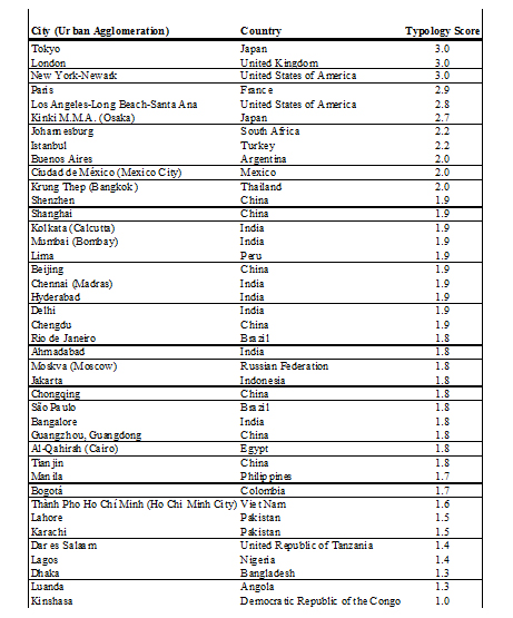
Table1: Projected megacities typology scores (sorted by score); 3 represents highly integrated, 1 – loosely integrated
End Notes
[i] United Nations, Department of Economic and Social Affairs, Population Division (2014). World Urbanization Prospects: The 2014 Revision, Highlights (ST/ESA/SER.A/352).
[ii] ibid.
[iii] UN Habitat, State of the World’s Cities 2012/2013 (2013).
[iv] TRADOC Pam 525-3-0, 2-1c
[v] TRADOC Pam 525-3-1, 2-3.b(5)
[vi] Chief of Staff of the Army, Strategic Studies Group (April 21, 2013). “A Proposed Framework for Appreciating Megacities: A US Army Perspective,” Small Wars Journal. See also, Chief of Staff of the Army, Strategic Studies Group (June 2014). Megacities and the United States Army: Preparing for a Complex and Uncertain Future.
[vii] Dawn A. Morrison, Colin D. Wood, Timothy K. Perkins, Carey A. Baxter. 2016. “Extreme Environment Basing: Contingency Basing in Megacity and Dense Urban Environments,” Center for the Advancement of Sustainability Innovations (CASI), ERDC/CERL SR-15-DRAFT (Forthcoming March 2016).
[viii] United Nations, Department of Economic and Social Affairs, Population Division (2014). World Urbanization Prospects: The 2014 Revision, Highlights (ST/ESA/SER.A/352).
[ix] U.S. Census Bureau Online. Geography Reference Section. http://www.census.gov/geo/reference/urban-rural.html.
[x] For a good explanation of these metrics, see MIT’s Density Atlas project: http://www.densityatlas.org/
[xi] See Chief of Staff of the Army, Strategic Studies Group (April 21, 2013; June 2014).
[xii] Data is available upon request.
[xiii] GCRI. http://conflictrisk.jrc.ec.europa.eu/. Website hosted by the Joint Research Center of the European Commission; Center for Hazards and Risk Research - CHRR - Columbia University, Center for International Earth Science Information Network - CIESIN - Columbia University, and International Bank for Reconstruction and Development - The World Bank. 2005. Global Multihazard Frequency and Distribution. Palisades, NY: NASA Socioeconomic Data and Applications Center (SEDAC). http://dx.doi.org/10.7927/H45718Z5. Website hosted by CIESIN at Columbia University.
[xiv] Sukman, Daniel. “The Past as a Prologue: The Future of the U.S. Military in One Graphic.” The Strategy Bridge. Dec. 18, 2015. Retrieved from http://www.thestrategybridge.com/the-bridge/2015/12/20/the-past-as-a-prologue-the-future-of-the-us-military-in-one-graphic, Feb. 02, 2016.
[xv] See Chief of Staff of the Army, Strategic Studies Group (April 21, 2013; June 2014).
[xvi] E.g., City Prosperity Index (CPI), 2012, United Nations Human Settlements Programme, Global Urban Indicators Database; Global Power Index (GCPI) 2009, http://www.citymayors.com/economics/power-cities.html;http://www.citymayors.com/economics/power-cities.html Global Cities Index (GCI), 2014, by AT Kearney; Global Metromonitor, 2014, Brookings Institution, Metropolitan Policy Program; Mercer’s 2015 Quality of Living City Rankings, https://www.imercer.com/uploads/GM/qol2015/h5478qol2015/index.html.
[xvii] See Morrison et.al. (2016) for a detailed discussion and breakdown of how these, and other open source indices, were used to operationalize the megacity framework.
[xviii] "Textiles on the WTO Website" http://www.wto.org/english/tratop_e/texti_e/texti_e.htm. WTO Secretariat. See also, Hildegunn Kyvik Nordas (2004), “The Global Textile and Clothing Industry post the Agreement on Textiles and Clothing.” Geneva, Switzerland: World Trade Organization.
[xix] TRADOC Pam 525-3-6, 3-4b
[xx] The “Golden Hour” is the first hour following a trauma injury, which is considered the most critical for successful emergency treatment. Likewise, the “Platinum Ten” refers to the period in which medical personnel arrive on and assess the scene, initiate treatment, and transport for injured personnel.[xx]
[xxi] TomTom Worldwide Traffic Index, 2015, http://www.tomtom.com/en_gb/trafficindex/#/list.
[xxii] TRADOC Pam 525-3-6, 3-4a
[xxiii] Anurag Kotoky (September 11, 2014). “Mumbai Airport Slum Removal Sought by India Over Terror,” Bloomberg Business.
[xxiv] See Morrison et.al. (2016).
[xxv] EP 1105-3-1, E-4
[xxvi] Area calculations for Camp Diamondback were determined using ESRI GIS ArcMap 10.1 and images from Google Earth.
[xxvii] Tucker, Patrick. “Refugee or Terrorist? IBM Thinks Its Software Has the Answer.” Defense One, January 27, 2016. Retrieved from: http://www.defenseone.com/technology/2016/01/refugee-or-terrorist-ibm-thinks-its-software-has-answer/125484/?oref=d-channelriver, Feb. 02, 2016.
[xxviii] U.S. Marine Corps, “Improvised Explosive Devices (IED) B3L4118 Student Handout,” Pg8.