An Analytic Framework for Operations in Dense Urban Areas
William Hedges
Introduction
The U.S. Army Operating Concept, (AOC) Win in a Complex World, “provides the intellectual foundation and framework for learning and for applying what we learn to future force development under Force 2025 and Beyond.[i] The AOC focuses on important questions; this paper provides a relevant framework supporting how we go about attempting to answer two of the questions presented within the AOC: “what is the environment we think Army forces will operate in, and what is the problem we are trying to solve?”[ii] Both of these questions and potential resolution thereof are key to how we continue to tackle Army Warfighting Challenge #1, developing and sustaining a high degree of situational understanding against determined, adaptive threats. The AOC provides due consideration to anticipated threats and the future operating environment (OE) by outlining five characteristics of the future operating environment with likely significant impact on land force operations:
(1) Increased velocity and momentum of human interaction and events;
(2) Potential for overmatch;
(3) Proliferation of weapons of mass destruction;
(4) Spread of advanced cyberspace and counter-space capabilities;
(5) Demographics and operations among populations, in cities, and in complex terrain.[iii]
Though the latter characteristic is the most compelling, it is important to note that the other future OE characteristics would indeed be exacerbated by the conditions found in dense urban areas (DUA). This paper provides a relevant analytic framework in support of framing, mapping, and developing courses of action (COA) for operations occurring in DUA today and in the future.
Background I – Dense Urban Areas
Discussion regarding DUA-oriented environments usually center on the roughly 28 megacities on the planet today. However, the increasing global pace of urbanization is not confined to just a megacities issue or perspective; recent United Nations studies portend a 60% population surge in urban areas by 2030.[iv] Despite the scale and complexity of the world’s megacities, there are almost 850 cities with populations between 500k and 9.9m – in essence, “middleweight” cities[v] that also represent interactively complex operating environments. Environments which may feature a dense and diverse population mix; further complicated by the potential for loose integration[vi], a multitude of networks, and potentially volumes of big data[vii] that present noteworthy challenges for information collection, much less its parsing, characterization, and understanding.
According to the National Intelligence Council’s Global Trends 2030: Alternative Worlds, precipitous changes in world demographics are expected to perpetuate significant changes, or megatrends, in the world’s diplomatic, economic, and military power.[viii] Such change may undoubtedly lead to a potentially volatile and uncertain security environment where US interests and related national security concerns are increasingly vulnerable to a variety of actors and a range of threats.[ix] In accepting that cities/dense urban areas represent the nexus of the megatrends alluded to above, the potential for US forces to operate in DUA is significant today and increasingly probable in both the near and far terms. Which presents the following questions, how do US forces develop critical situational understanding of such environments, and what would constitute a viable analytic framework for developing and placing that understanding into relevant and applicable context?
Background II – IPB: A Dated Methodological Approach
For the better part of four decades, Army intelligence has tackled operational challenges via an approach known as Intelligence Preparation of the Battlefield (IPB), which was embedded within the Military Decision-making Process (MDMP). Even though the Army has revised a great deal of its doctrine and associated tactics, techniques, and procedures in an effort to adapt to an evolving OE landscape, our situational understanding largely remains anchored to IPB’s role as a MDMP catalyst for all environments. IPB’s orientation is towards linear engagement areas and a specific threat methodology and model. It is essentially reductionist and quantitative in nature, still supportive of a structurally complex OE; but, often fails to gain sight of the dynamics between the components of problems within an interactively complex system. The dense urban area problem approach must be qualitatively focused and employ diverse heuristics[x] lines of effort rather than the rigidity invoked by the IPB analytic framework.[xi]
The products for each step of IPB are not conducive to an interactively complex OE. These products fail to adequately unify the different elements found within the OE while seeking alignment to a threat or system of opposition[xii] picture. One pointed example associated with the IPB construct, lies with the challenge of incorporating religion as an operational data layer specific to an OE. Presently, an analytic team focusing on a religious-themed impact – central to operational planning, would focus on the operational variables captured within a given city’s OE assessment (note though that doctrinally, religion at present is not represented as a “stand-alone” variable). Such a religious-themed search (within PMESII-PT[xiii], F-ASCOPE[xiv], SWEAT-MSO[xv], DIMEFIL[xvi], and even METT-TC[xvii] analysis) would potentially yield multiple and disparate religious informational elements, which is to be expected. However, the IPB construct does not afford a clear step for tying together several “like” elements into a single operational data layer and illustrating or modeling the relationship of that system upon other systems (IPB does not accommodate “modelling” until step 3 and that step/model is threat-centric).
The relevance of the example above highlights a significant gap within the IPB framework/process and the inability to truly support comprehensive mission analysis and problem framing, especially for the multitude of data layers found in DUA. Though religion is often citied within an OE assessment, there is little conduit via IPB to truly discern analytic value. In IPB, there exists the potential for such data to be “not considered” since it may be interpreted as having little to no value in either describing the threat or the threat COA. This example highlights another IPB-related challenge. How the Army doctrinally captures relevant operational variables is potentially problematic given that a very relevant operational variable like religion (or perhaps even tribal/familia factors) is buried within our PMESII-PT or F-ASCOPE snapshots despite the data point that religion continues to emerge as a dominant theme for a multitude of current and perhaps future operating environments.[xviii] IPB’s role and suitability as a MDMP catalyst, directed towards an interactively complex environment focused on a city-system environmental challenge or a hybrid warfare[xix]-oriented system of opposition – remains questionable.
An Urban Analytic Framework: City as a System
Dense urban areas represent the higher nexus of interactively complex operating environments. The IPB process’ end-state provides an inadequate degree of situational understanding for such complex environs given its inherent threat-oriented slant versus a city as a system or all-encompassing environmental perspective. Adoption of this city as a system perspective will require adaptation of a significant portion of our Army doctrine and thus, lead to an urban analytic framework tailored to address the operational data layers found within urban centers, their environmental dynamism, and their state of connectedness.[xx]
One such urban analytic structure has been developed by CAERUS Associates, championed by the Combatting Terrorism Technical Support Office (CTTSO),[xxi] and has been applied by elements within the special operations community. The overarching concept behind this framework is alignment with systems thinking, focusing attention on the relationships between different parts of the environment and working to understand the cumulative effects of these interactions.[xxii]
The CTTSO analytic framework certainly offers dividends as well as potential shortcomings. “Shoehorning” another analytic framework into IPB should not be the first objective. Instead, the Army should be focused on: the capture of the DUA’s operational data layers; the display or modeling of those data layers; determination and analysis of city system Environmental Centers of Gravity (E-COG); the potential impact on friendly or threat/ systems of opposition COA; and the impact or urban consequences of friendly/threat COAs upon the city systems. All of these objectives should be contained within an analytic framework dedicated to understanding interactively complex and adaptive operating environments (i.e. DUA).
Creating a Tailored Urban Analytic Framework
The creation of a tailored urban analytic framework would build upon the merits of the CTTSO/CAERUS construct and incorporate additional elements essential to both development of a pertinent intelligence-oriented model and relevant support to Army staff action planners during the course of MDMP. Such a framework would stand-alone; and be the primary analytic process that develops situational understanding for DUA.
Such a framework could potentially look much like the following:
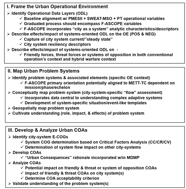
Figure 1. Proposed Urban Analytic Framework
Framing the Urban Operational Environment
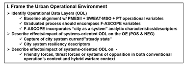
Figure 2. Framing the Urban Operational Environment
This first step is an initial assessment construct of a city’s operational environment. It represents an assessment of existing OE conditions developed from both operational and mission variable analysis within the commander’s area of operations, the area of influence, and the area of interest. This assessment is integral to planning and facilitating friendly force operations. The data visualization capture should provide for an initial city/system modeling construct, illustrating individual components within each city system, leading to the ability to display a layered (system upon system) operational view.
Before we can begin to frame the problem we must first understand the components of the potential problem system, therefore it begins with identifying the operational data layers associated with a specific urban environment. Note that historical application of IPB towards DUA usually resulted in a limited operational data layer perspective (i.e. three layers: terrain, weather, and the threat); yet, urban OEs (e.g. megacities and “middleweight” cities) will likely involve a multitude of diverse data layers.
Characterization or context of how the data applies assists the process of identifying relevant urban area data layers. Figure 3 captures the common themes related to the dimensions often associated with DUA,[xxiii] and in effect, guides the “fit” of a data layer within the urban OE.
Using Figure 3 as a general guide, an initial analysis of population, infrastructure, and physical environment variables (described within the CAERUS framework as the Urban Triad[xxiv]) would yield critical insight to the operational data layers relevant to a given DUA (See Appendix: “Select examples of operational data layers within Dense Urban Areas.” The cited examples are reflective of an initial PMESII + SWEAT-MSO + PT analysis.)[xxv]
Further maturation of these initially identified data layers will be required in which F-ASCOPE context, particularly the “flow” or relationship aspect, is geared towards a “city as a system” perspective, and thus lay the groundwork for both individual system and system-on-system interaction analysis.[xxvi] Each systems’ perspective should continue to evolve, leading to a description of the positive and negative effects/impacts of the systems- oriented operational data layers on the OE from a holistic standpoint.[xxvii] The overarching objective is to capture the city systems’ status currently or from a “steady state” standpoint.[xxviii] The resultant capture should include additional descriptors of each systems’ resident capabilities which enable achieving or maintaining a degree of resiliency against internal or external forces/factors/variables.
This urban OE framing concludes with a transition from our examination of the city systems as federated entities, to one in which an analytic team then describes the effects/impact of systems-oriented data layers on friendly and threat forces, the latter of which may be addressed as systems of opposition[xxix] in order to achieve both a conventional and a hybrid warfare context.
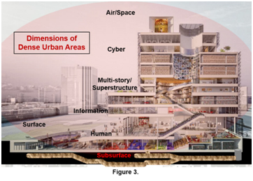
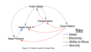
Mapping Urban Problem Systems
Figure 4. Mapping Urban Problem Systems
Mapping the urban problem system elaborates on the problem through system map visualization. Transferring this knowledge to a map/picture supports the identification of key accumulators/nodes and flows integral to the problem system itself and our understanding of the system in general. This mapping process assists key input to:
- Friendly forces concept of operation;
- Running intelligence estimate;
- Development, evaluation, and refinement of priority intelligence requirements;
- Facilitating the initial scoping of a unit’s intelligence collection plan.
Whereas the initial urban OE framing is largely a strategic and operational undertaking (e.g. geographic combatant command aligned to corps and divisions), the mapping of the urban problem system step may largely fall to BCTs and below. In tactical echelons, F-ASCOPE evaluation and subsequent analysis[xxx] would be aligned with the applicable METT-TC variables, dependent upon specific mission, operational phase context, and the respective operationally engaged echelon. This mapping step should incorporate data central to understanding complex adaptive systems, essentially alluding to global graph[xxxi] utilization; human domain mapping; human social culture behavior modeling; and emergent state phenomena.[xxxii]
A definitive by-product of framing the urban OE, specifically the analysis of the relevant operational data layers and their systems’ orientation, yields select identification of those problem systems along with their associated sub-elements (see Figure 5[xxxiii]).
Concept Mapping is a key component of problem framing and is linked to TRADOC PAM 525-5-500, “Commander’s Appreciation and Campaign Design,” 200).
As the concept and geospatial mapping functions come together (See Figure 6 on following page) the data therein is critical towards enabling an analytic team the means to convert system patterns of operations (to include systems of opposition) to graphics. This visualization may take on a form similar to elements within the present IPB process in which situation and event-like templates are generated; thereby illustrating system and city key “terrain,” potential/necessary objectives, named areas of interest, target areas of interest, and associated decision points.
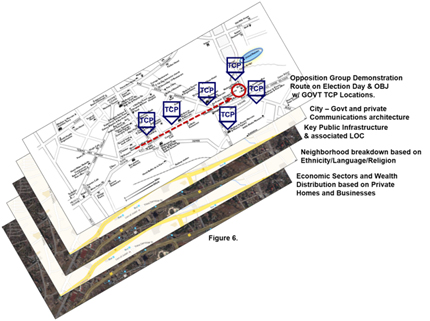
Figure 6 (above) is an example of the Urban OE visualization discussed on the previous page. In this figure’s example, significant operational data layer examples (culled from the examples presented in the Appendix) were combined and framed in a visual array for a select portion of a city in support of a specific event.
In sum, mapping the urban problem system embodies a visual representation of the elements of the problem and their relationships. This step is an integral element towards truly facilitating and cultivating a deeper understanding of each system’s role, impact, and effects. This step illustrates and affords:
- General understanding (and simplification) for how disparate parts of the system interconnect and interact to produce emergent phenomena and provides a visual means supporting systematic study of system parts.[xxxiv]
- Structural diagramming showing directional flows of resources and the connections between accumulators/nodes (based on the initial F-ASCOPE analysis). This diagramming technique results in a visual track of resource flow(s) through the problem system while building a holistic picture of the system(s) within the OE.[xxxv]
- Understanding how the population, infrastructure, and key actors relate to the physical terrain. This in turn aids in revealing the territorial logic shaping the spectrums of behavior[xxxvi] of the key actors within the urban OE and potentially puts a face to each of the city’s operational data layers.[xxxvii]
Fruition of the latter comment above is intrinsic to a maneuver commander’s vision and intent as well as the unit’s urban battlespace (or engagement) management. Analysis and subsequent data mapping should answer several significant questions relevant to friendly force operations, strategies, and objectives – contributing to the commander’s understanding of system/city (urban) metabolism.
Developing & Analyzing Urban COAs
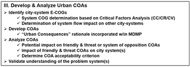
Figure 7. Develop & Analyze Urban COAs
This framework then moves from describing the problem to how to influence it[xxxviii] via identification of Environment Centers of Gravity (E-COGS). E-COGS are those accumulators/nodes and flows that appear to play a more central role in the viability and functionality of the system. E-COGs are the critical elements that truly enable the system to function to the degree required in order to fulfill its inherent system and city objective(s). E-COG identification may be aided by the location of potential E-COG within a city’s overall systems diagram, the potential E-COG’s centrality (degree of accumulators/nodes and flows interaction) and its loop positioning (where a closed sequence of causes and effects occurs)[xxxix]
E-COG application extends traditional COG analysis from one that is adversary centric to one that embraces a systems-supportive environmental perspective. E-COG analysis resides within the premise that population, infrastructure, and the physical environment all provide resources to both friendly forces and systems of opposition as well as all those who rely on the city’s systems for well-being, sustainment, and progress. There may be multiple E-COGs “in play” at the same time within the same DUA, with each or a combination thereof, extremely susceptible to change over time.
The key to E-COG application is giving each system found within the population, infrastructure, or environment (e.g. water, energy, communications systems, etc.) greater context or depth by stating the objective(s) of each of those entities (as opposed to a “threat intent” in traditional COG analysis). Alignment of an objective to a system enables tailored application of current COG or critical factors analysis using critical capabilities, critical requirements, and critical vulnerabilities descriptions, rendering a more refined intelligence portrait of system interaction and the impact on the DUA. E-COG identification, partnered with relevant critical factors analysis provides an important conceptual link between framing the environment, identifying and characterizing the problem systems,[xl] and creating a model[xli] that incorporates the elements/systems therein.
E-COG identification within the problem(s) system(s) remains key towards developing tentative courses of action (COA) designed to affect the E-COG and thus achieve a friendly force desired end-state.[xlii] Select examples of related system/E-COG-related friendly COAs may center around degradation of the E-COG to deny resources to a system of opposition or a clearly defined threat entity;[xliii] and reinforcement of an E-COG in order to ensure that that E-COG functions and contributes positively to the system users.[xliv]
This framework enhances the operations planning staff’s ability to determine COA acceptability criterion specific to DUA through an urban consequences rationale developed within MDMP.[xlv] Urban consequences COA considerations may also be assisted by using imaginative advanced structure analytic techniques (e.g. outside-in thinking and morphological analysis[xlvi]) to forecast how the COA may affect other not-yet-analyzed systems.[xlvii] This process may also serve as a check against baseline system-on-system effects analysis, in which a relationship outcome may not be sufficiently captured or the relationship effects are now unfavorable to friendly force operations.
Preparing for the AOC’s Future Operating Environment
DUA require an analytic framework specifically tailored to accommodate a city’s system diversity. The analytic framework presented provides a structure that incorporates urban operational data layers and city as a system context and perspectives. It is a catalyst towards addressing AOC questions like “what is the environment we think Army forces will operate in, and what is the problem we are trying to solve?” The potential for US forces to operate in DUA remains significant today and in the far term given the global pace of urbanization and the world’s megatrends involving more complex diplomatic, economic, and military power. These trends are largely population-centric, and thus urban centric. As the Army’s potential OE landscape continues to evolve, so must the Army’s doctrinal framework, processes, and applications evolve as well. This framework is representative of our human domain[xlviii] efforts (e.g. data collection and analysis) in understanding the human interface resident within DUA; it is an education enabler that prepares the Army for the “unknown.”[xlix] It complements the Army’s human dimension[l] educational effort as well, guiding both situational understanding and the knowledge acquisition necessary for managing and influencing an Army team (and those within the human domain) through a potentially challenging and relatively unknown problem set. Gaining further insight to the dynamics between the components of problems within a decidedly complex urban system and the potential for hybrid warfare therein will not be easy; but, it must be a requirement. Development of situational understanding for dense urban areas remains a critical component of Army planning; such understanding demands relevant context and a framework appropriate for content application.
Appendix
Select Operational Data Layers Examples Found Within Dense Urban Areas
The following examples are grouped or nested within an overarching concept (e.g. human geography) and shaped initially by the appropriate dense urban area dimensional perspective (see Figure 3 on page 9):
-
Human geography of the “cityscape” (Human/Cyber/Information/Surface)
- Ethnicity/Language/Religion
- Social groups and organizations
- Select demographic group patterns of life capture
- Attitudes; social networking near-term sentiment analysis
- Health & medical
- Significant events
-
Relative degree of urbanization & associated demographics (Human/Cyber/Information/Surface)
- Geospatial visualization of dense urban core and peri-urban
- Distributions of wealth (wealthy core vs. poor core & poor periphery (geospatial graphic representation))
- Familia/tribal pockets; relationships, ideology influencers
- Demographic dependencies on government or armed groups
- Grievances; Identified coping mechanisms; opportunities to create resiliency
- Identification of what one knows of the “social state,” group or population movement (human condition mapping)
-
Analysis of urban inflow & outflows (Human/Cyber/Information/Surface/sub-surface)
- Sewage, Water, Electricity, Academia, Trash, Medical, Safety, Food
- Demographic/social movement (Dense urban core to peri-urban areas & peri-urban areas to dense urban core)
- Traffic and commuter patterns (Road/rail/pedestrian/maritime/air)
- Wealth and economic distribution patterns, means of economic control and infrastructure controls (Define “elite, middle-class, and poor” based on present conditions)
- International trade flows into/from city (incl. Air and sea ports/other (rail/ground))
-
Economics (Human/Cyber/Information)
- Basis and state of financial capital
- Type/flow of commodities and remittance
- Potential for stabilizing effects of illicit economies
- Unemployment; rates, socio-economic aspects of affected divisions w/in general population
-
Systems of opposition (Human/Cyber/Information)
- Identification, description, and their core interests
- Opposition methods, span, and degree of control
- System rivals/allies (active/potential)
- Level of demonstrated or potential access to advanced lethal/military technologies available to the system of opposition
- Population’s reliance/dependence on the system (security, aid, conflict resolution, social rule, financial assistance) and impact on terms of support/acceptance of the system’s authority or influence
-
Security controls/overwatch mechanisms (Human/Cyber/Information)
- Government security forces; degree of presence, influence, and control
- Internet and social media penetration; government internet policy
- Identification of political/military influencers
- Population’s reliance/dependency on the city government (admin services, property rights, conflict resolution, social welfare/aid, education, and health) and impact on terms of support/acceptance of the government’s authority or influence
-
Other “Actors” (not identified/discovered above) (Human/Cyber/Information)
- Local administration (governance, military, law enforcement)
- Religious/Business/labor
- Illicit network “leads” or commodities providers
- Hostile actors (not otherwise captured w/in system of opposition; e.g. gangs)
End Notes
[i] “The US Army Operating Concept,” TRADOC Pamphlet 525-3-1 (Oct 14), i (Foreword).
[ii] Ibid. iii (Preface).
[iii] Ibid. 11-12.
[iv] “The US Army Operating Concept,” TRADOC Pamphlet 525-3-1 (Oct 14), 12.
[v] “Readiness in an Urban Era: Implications for the US Army,” Strategic Initiatives Group – Lyceum, School of Advanced Military Studies (SAMS), Ft. Leavenworth, KS (May 15), i.
[vi] US Army Chief of Staff’ Strategic Studies Group (Megacities), “A Proposed Framework for Appreciating Megacities: A US Army Perspective,” Small Wars Journal (Apr 2014), 2. System typology often featuring decentralized and informal systems, low quality infrastructure, and unregulated flow capacity.
[vii] Luciano Florida, “The Fourth Technological Revolution,” Oxford, UK, Oxford University Press (May 2014), 14-15.
[viii] National Intelligence Council, Global Trends 2030: Alternative Worlds (Washington DC: Office of the Director of National Intelligence (2012), ii.
[ix] SAMS, “Readiness in an Urban Era: Implications for the US Army,” 1.
[x] Heuristics are strategies using readily accessible, though loosely applicable, information to control (or steer) problem solving.
[xi] “Commander’s Appreciation and Campaign Design,” TRADOC Pamphlet 525-5-500 (Jan 2008), 6.
[xii] Understanding the Threat as a System of Opposition,” David Pendall, COL, USA, White Paper (Jan 2014), 4.
[xiii] Political, Military, Economic, Sociological, Infrastructure, Information – Physical Environment & Time. “Brigade Combat Team Intelligence Techniques,” ATP-2-19.4 (FM 2-19.4) (Feb 2015), 1-3.
[xiv] Flow – Area, Structures, Capabilities, Organizations, People & Events. ATP 2-19.4, B-21.
[xv] Sewage, Water, Energy, Academics, Trash – Medical, Safety, & Other Considerations. “Engineer Reconnaissance,” FM 3-34.170 (Mar 2008), 6-14.
[xvi] Diplomatic, Information, Military, Economic, Financial, Intelligence, and Law Enforcement. Vulnerability Analysis Workbook, Understanding the Threat, Vol 1, US Army Asymmetric Warfare Group, Ft. Meade MD (Jun 2008), v.
[xvii] Mission, Enemy, Terrain & Weather, Troops & Support Available – Time Available & Civil Considerations. ATP 2-19.4, 1-3.
[xviii] Re-scoping how the Army views and applies applicable operational variables to a problem set like dense urban areas, could significantly add data dimensions not presently considered for urban-related mission analysis.
[xix] Frank Hoffman, LtCol, USMCR (Ret.), “The Janus choice: Defining today’s multifaceted conflict,” Armed Forces Journal (Oct 2009). Combat operations characterized by the simultaneous and adaptive employment of a complex combination of conventional weapons, irregular warfare, terrorism and criminal behavior to achieve political objectives.
[xx] “City as a System, Analytic Framework,” Version 1.0, CAERUS Associates and the Combatting Terrorism Technical Support Office, Alexandria, VA (Jun 2015), 1.
[xxi] CTTSO was established in 1999 by the Assistant Secretary of Defense for Special Operations/Low-Intensity Conflict. It is charged with providing a forum for interagency and international users to discuss mission requirements to combat terrorism, prioritize requirements, fund and manage solutions, and deliver capabilities.
[xxii] “City as a System, Analytic Framework,” 1.
[xxiii] There exists minute differences for representing the dimensions of the urban landscape between various DoD entities as part of the dense urban area community of interest.
[xxiv] “City as a System, Analytic Framework,” 25-26. The CAERUS/CTTSO Urban Triad Paradigm conceptually borrows from Joint Publication 3-06, “Joint Urban Operations,” and contributes significantly towards defining the unique features of urban environments. This paradigm is represented by population (PMESII), infrastructure (SWEAT-MSO), and physical environment and time (as a latter sub-set of PMESII-PT application.
[xxv] “Dense Urban Areas & Megacities Challenge,” Brief to US Army Intelligence Center of Excellence representatives, Dr. Rolf Halden, Arizona State University Research Enterprise (ASURE), Phoenix, AZ (24 Sep 15), slide 19. Multi-variable consideration creates multiple lines of information ingest, protects against data gaps, and thus better informs follow-on mapping and modeling efforts.
[xxvi] David J. Kilcullen, “The City as a System: Future Conflict and Urban Resilience,” The Fletcher Forum of World Affairs, VOL 36:2 (Summer 2012), 36.
[xxvii] Capture and analysis of negative effects/impacts regarding urban operational data layers is key to informing friendly COA development. There may be circumstances in which the effects of a city-related system are so adverse that an environmentally imposed condition like area anti-access/area denial is present.
[xxviii] Comparing/contrasting current city steady-state with a desired future state, based on the urban OE’s operational data layers analysis and a Commander’s guidance/mission analysis will also require a structured analytic outline (see DIA & CIA structured analytics regarding diagnostic techniques, argument mapping, and contrarian techniques).
[xxix] Pendall, (Jan 2014), 4.
[xxx] Identification of critical city system flows may not be readily apparent to a planning staff via F-ASCOPE regarding a dense urban OE’s effects on operations and the implications therein. This contention is reinforced by the CAERUS framework’s apt descriptors of accumulators and nodes as related, yet hardly interchangeable concepts. These terms may require doctrinal re-visit in light of the critical application of F-ASCOPE in support of dense urban terrain analysis.
[xxxi] A global graph is a scalable, operational environment-specific database that identifies, stores, and updates the relationships between hundreds of thousands to millions of entities. The relationships between entities are stored as fusion triples, i.e., as object-predicate-object. Future analytic teams would employ algorithms and artificial intelligence means to discover and explore not only those entities and relationships that are obviously relevant to their unit's mission; but more important, to discover and track those entities which were not previously known to the unit. Global graphs are foundational and fundamental to all future analytics, to understanding threat and non-threat networks of people, places, procedures, and underlying motivations, and perhaps most importantly, to understanding complex operational environments as complex adaptive systems.
[xxxii] Tom Pike and Eddie J. Brown, “Populations as Complex Adaptive Systems: A Case Study of Corruption in Afghanistan,” Small Wars Journal (Aug 2011), 3.
[xxxiii] “City as a System, Analytic Framework,” Brief to US Army Intelligence Center of Excellence, CAERUS Associates and the Combatting Terrorism Technical Support Office, Alexandria, VA (14 Jul 2015), slide 16.
[xxxiv] “City as a System, Analytic Framework,” 30.
[xxxv] Ibid. 30-31.
[xxxvi] “Dense Urban Areas & Megacities Challenge,” Brief, Dr. Rolf Halden, ASURE, terminology discussion.
[xxxvii] “City as a System, Analytic Framework,” 35.
[xxxviii] Ibid. 37.
[xxxix] Ibid. 39.
[xl] Ibid. 38.
[xli] Comparison between two or more dense urban OEs will likely yield contrasting elements or system-specific-interaction differences; therefore, model-linked experimentation efforts may require a very specific dense urban OE test subject and scenario in order to adequately convey and capture the resultant impact of a critical variable upon the other resident systems within the OE.
[xlii] “City as a System, Analytic Framework,” 41.
[xliii] Ibid.
[xliv] Ibid.
[xlv] Ibid. 42. Urban operational consequences are not presently captured within MDMP as part of step 4 (COA Analysis – War Game) and step 5 (COA Comparison). A planning staff may need to return to the urban OE framing and mapping steps in order to re-assess how the friendly/threat COAs will impact the system-specific operational data layers.
[xlvi] Richards J. Heur Jr., and Randolph H. Pherson, “Structured Analytic Techniques for Intelligence Analysis,” Washington, DC, CQ Press – Division of SAGE (2011), 108.
[xlvii] City as a System, Analytic Framework,” 42.
[xlviii] Totality of the physical, cultural, psychological, and social environments that influence human behavior to the extent that the success of any military operation or campaign depends on the application of unique capabilities that are designed to influence, fight, and win in population-centric conflicts.
[xlix] Thomas E. Ricks, “The Generals,” New York, NY, Penguin Press (2012), 346. The author’s context was in relation to “FM 100-5: Operations,” in which that document was categorized as “. . . emphasized training, which prepares soldiers for the known, far more than education, which prepares them to deal with the unknown.”
[l] Cognitive, physical, and social (CPS) components of Soldier, civilian, leader, and organizational development and performance essential to raise, prepare, and employ the Army in unified land operations.