Enhancing Collaboration Through Shared Understanding Toward a Better Understanding
Russell Ravenhorst, Ryan Satterthwaite, Mark Kaperak, and Sungwook Kim
“All Counterinsurgency is Local” is the title of a 2008 article by Thomas H. Johnson and M. Chris Mason to help explain why the US was losing in its efforts to help the Government of Afghanistan fight the growing Taliban insurgency. Johnson and Mason pointedly focused their article on an appeal to shift US strategy in Afghanistan; however, the critical underlying point is about the importance of understanding the operational environment.[i] Expand the concept of locality in counterinsurgency to include humanitarian assistance, disaster relief, security force assistance, foreign internal defense, or any number of activities in which the US Military or US Government (USG) Agencies could conduct to prevent or respond to crises overseas and it reinforces the notion of gaining a deep understanding of the operational environment. If the US strategic and operational decision makers understood key aspects of local Afghan culture, life, history, etc., then they would likely have pursued an alternative and possibly more successful strategy to assist the Government of Afghanistan in countering the Taliban insurgency.
The issue of gaining and sharing a deeper understanding of the operational environment is not isolated to counterinsurgency in Afghanistan; it proliferates across the USG (Department of Defense [DOD], Department of State [DOS], and other governmental agencies) and also exists in disaster relief operations, counter narcotics operations, and any number of contingencies in which the USG may respond.[ii] USG stakeholders and potential partners (other countries, inter-governmental organizations [IGOs], and non-governmental organizations [NGOs]) require a higher degree of shared understanding of current and potential conflict areas, as well as other places where they may find themselves working in order to achieve greater unity of effort and more effectively accomplish their objectives. Through a review of a US Special Operations Command (USSOCOM) and US Agency for International Development (USAID) human terrain mapping initiative, a case study of recent events in Mali where this initiative would have had positive effects, and an assessment of shortfalls of human terrain analysis, this article expounds upon the requirement for reaching a deeper, shared understanding to achieve unity of effort.
The Joint Sahel Project and SERENGETI
USSOCOM and USAID came together in 2013 in order to develop a capability that would increase inter- and intra-governmental information sharing and collaboration. The aim was to inform decision makers at a higher rate of speed and inform the common operating picture, creating unity of effort, and engender Whole of Government approaches.
In US Africa Command’s (USAFRICOM) area of responsibility, USAID and USSOCOM, in consultation with USAFRICOM, are in the midst of a joint and interagency project to develop a more comprehensive, common understanding of the risks and resilience factors in the Sahel region of Africa with the intent of averting potential crises.[iii] USAID and USSOCOM developed the Joint Sahel Project to support Presidential Policy Directive 23 (PPD-23) “as a joint vision between the USSOCOM Commander, ADM William McRaven and USAID Administrator, Dr. Rajiv Shah. As the project developed, the staffs of USSOCOM and USAID received guidance to ensure the effort supported ongoing policy and strategic initiatives including PPD 23 and the DOS led Sahel-Maghreb Working Group.”[iv] This was to strengthen the USG’s “capacity to plan, synchronize, and implement security sector assistance through a deliberate and inclusive whole-of-government process that ensures alignment of activities and resources with our national security priorities.”[v]
The Joint Sahel Project is developing planning capacity, while cultivating a shared understanding among organizations, agencies, and even nations. USAID and USSOCOM currently use the “Special Environment Related to Non-traditional Geospatial Topography Intelligence” (SERENGETI) software platform to gather, sort, and display varied levels of information that comprise many aspects of human geography. The SERENGETI technology has the ability to develop a world-wide community of interest allowing for the rapid ability to predict crises through both indigenous based and non-traditional, Africa centric information. It is based on the USAID Office of Conflict Mitigation and Management’s Conflict Assessment Framework (CAF 2.0) which,
represents USAID’s unique methodological approach for implementing a conflict assessment to help its USAID missions and operating units better evaluate the risks for armed conflict, the peace and security goals that are most important in a given country context, how existing development programs interact with these factors, how the programs may (inadvertently) be doing harm, and where and how development and humanitarian assistance can most effectively support local efforts to manage conflict and to build peace.[vi]
This capability “highlighted the need to act to prevent conflict in Niger and Burkina Faso as the areas most at risk in the region.”[vii]
While CAF 2.0 is normally applied to single nations, SERENGETI expands upon the framework in a regional and potentially global context. One of the critical aspects of SERENGETI that contributes to collaboration, shared understanding, and unity of effort is the platform and its contents exist on unclassified networks, which allows for rapid information sharing across multiple levels of USG and international stakeholders. Registered users can push information into the system, which protects the system’s integrity, while a core group of administrators also pull information into the system, loading thousands of reports, area surveys, and digital mapping data from a variety of sources. Products of SERENGETI are geospatial and textual, providing context of transnational, socio-political, economic and cultural structures. The project is about collaboration, information sharing, and developing a holistic regional view so users will have an expedited capability to plan for and respond to crises.
Examples of the types of information that administrators pull into the database are unclassified reports by individuals, law enforcement agencies, IGOs, NGOs, DOD, and others, such as USAID’s Famine Early Warning System Network (FEWS NET). Data from the FEWS NET is an example of information that compliments the predictive capabilities in SERENGETI, which can help preempt or limit the severity of crises.[viii] The information is as varied as the individuals that provide it by way of official reports, blogs, Twitter feeds, Facebook pages, etc. One actual example involved open source reports from NGOs in an area regarding conditions they encountered, such as status of roads and infrastructure, conflict locations, key groups and powerbrokers in the area, types of diseases, etc. Another real world example looked at a blog written by a man tracing the ancestry of his dog in Africa. He described cultures, road conditions, airport conditions, and more with pictures throughout Africa, as he followed the trail of his dog’s ancestry. [ix] On the surface, this type of information may look unimpressive, but it becomes very important, especially in the context of planning for possible contingency operations in the region. While none of this is viewed as traditional intelligence, it is extremely useful, easily shared, and has the potential to better inform decision makers and encourage collaboration throughout the USG and partner nations.
The appendix contains several screenshots from SERENGETI that show Mali and neighboring countries and illustrates the capability of layering geospatial and textual data.
Missed Opportunity in Mali
For the past several years, Mali has been in turmoil due to a convergence of internal as well as external factors such as illicit trafficking, Violent Extremist Organizations (VEOs), and Tuareg insurgencies against the Malian government. Most recently, in March 2012, the Malian government was overthrown in a military coup. Following the coup, the Malian army suffered repeated defeats at the hands of Tuareg separatist groups seeking independence for northern Mali. As of early January 2013, Islamic extremist groups, such as Al Qaeda in the Islamic Maghreb (AQIM), took advantage of the power vacuum and took control of major cities in the north.[x] As of January 2014, eleven international aid agencies warned that northern Mali was facing a new food crisis as a result of poor harvests and political instability.[xi] This is cause for concern as the USG is currently the leading provider of humanitarian aid in response to the regional food security crisis. Furthermore, the prospect of an expanded safe-haven for AQIM and other extremists could threaten regional security, thereby impacting western interests. VEOs have kidnapped Westerners for ransom and also carried out a number of terrorist attacks throughout the region. Since early 2012, USG officials have been concerned that AQIM and affiliates could leverage their expanded presence in northern Mali to carry out training, expand recruitment, and advance transnational terrorist plots.[xii]
A recent Congressional Research Service (CRS) report states that Malian activities also raise questions regarding the strategic design and effectiveness of previous USG efforts to promote stability, democracy, civilian control of military, and effectively counter terrorist threats in Africa.[xiii] The USG continues to consider the best way to handle the situation in Mali because of the effects it could have on not only the region, but on areas beyond Africa as well. A regional food shortage, ethnic conflicts, and violent extremists operating in the area are just a few of the reasons why building a more complete, shared, and common understanding of the region would greatly facilitate any future efforts the US and other interested parties might partake to effectively mitigate the ongoing crisis.
Prior to the 2012 military coup, Western nations highlighted Mali as the model for stability and democracy in Africa. At the same time, USAID’s Fragility Index rated Mali as one of the most fragile, at-risk countries in the world.[xiv] In hindsight, the USG and partner nations would have benefited from the ability to holistically depict human factors of resilience and drivers of conflict and instability through a regional lens such as that provided through SERENGETI. Effective analysis within a defined area would have better informed long term development activities. This evolved, shared understanding among key stakeholders may have helped define decision points and identify future problems to inform strategies and mitigate the risks associated drivers of conflict and instability. SERENGETI would have greatly assisted in increased collaboration, enabling the coordination and synchronization of resources for balanced security and stability efforts for all involved. This may not have prevented the 2012 military coup and rapid deterioration of the country, but it provides credence to the critical requirement for increased collaboration and a better understanding of the operating environment.
Assessment of Shortfalls
While the utility of an initiative like the Joint Sahel Project and SERENGETI is apparent, there will always be challenges with getting the right information to the right person at the right time in order to make timely and well informed decisions. To maximize collaboration, the database should remain unclassified, offering ease of access and sharing, but that raises the question of responsibility for funding, maintenance, and management. There is also the question of information credibility and validity; with competition for resources growing ever fiercer, especially in a crisis area, biased information could negate the positive benefits of the program.
As portions of SERENGETI deal with analysis of human terrain, some negative connotations arise. A cursory Google search of the term “human terrain” will bring up a plethora of articles on the Army’s Human Terrain System (HTS). The HTS involves deploying social scientists to Afghanistan to advise military commanders on how to better understand and interact with the local population. Some critics of employing anthropologist in support of the HTS posited three main arguments against it: 1) deploying social scientists to conflict areas could endanger the people being studied and lead all anthropologists to be viewed as spies; 2) anthropology is not predictive and therefore not useful for military operations; and 3) anthropology should not be used to subjugate unruly people.[xv] The HTS was recently under fire for several issues including ethical practices such as using social scientists to provide information to a commander that may eventually lead to a kinetic strike. For all of the controversies surrounding the HTS or mapping the human terrain, it has at least brought renewed attention to the need for better understanding by USG stakeholders when planning and conducting operations in regions of conflict.
Conclusion
A 2010 Center for a New American Security (CNAS) report titled “Fixing Intel: A Blueprint for Making Intelligence Relevant in Afghanistan,” argued for changing the way the intelligence community approaches their profession with respect to countering the insurgency in Afghanistan. The authors found that the intelligence community was almost solely focused on the enemy, which as they note, should only be a small part of their focus in a “population centric” counterinsurgency strategy. The report also highlights a key intelligence community deficiency in sharing the right information from the lowest levels to the highest key decision makers; this creates information shortfalls lending to an incomplete understanding of the environment at the operational and strategic levels.[xvi]
There exists a recognized deficiency in the ways and means that the USG, partner nations, IGOs, and NGOs have attempted to work together toward common goals. More than twelve years of conflict in Afghanistan is evidence enough that USG agencies require more in depth understanding of their operating environments to achieve greater unity of effort in answering the nation’s call. Numerous experts have attested to these problems, yet no panacea exists to help alleviate this issue. USSOCOM and USAID have undertaken a partnership to increase their ability to collaborate toward mutual goals in the Sahel region of Africa, as well as other potential conflict areas. The Joint Sahel Project uses SERENGETI to enable a common understanding and has great potential to increase unity of effort within the USG and other interested partners.
If SERENGETI was widely available several years ago, the USG and other nations could have used it to better understand the environment within Mali to increase coordination among all stakeholders. They could have identified and helped to mitigate critical vulnerabilities of the USG and other nations’ strategies. Increasing the understanding of the factors of conflict and instability might have clearly identified the threats and led to better collusion against those threats. There will never be an acceptable substitute for first-hand experience and focused academic study of a given region. A contextualized knowledge model and focused interactive database such as SERENGETI is an extremely useful tool to achieve a better understanding of regional issues and thereby contributes to greater unity of effort across the USG and critical partners
Appendix
Select screenshots from SERENGETI layering data in and around Mali. Figure 1 shows a simple depiction of tribes overlaid with incidents of ethnic conflicts and terrorist acts. Figures 2, 3, and 4 can help demonstrate a population’s perspective of services provided by the government throughout the country, and lead to a better understanding of local/ tribal grievances. Figure 5 is an example of key linkages made using SERENGETI.
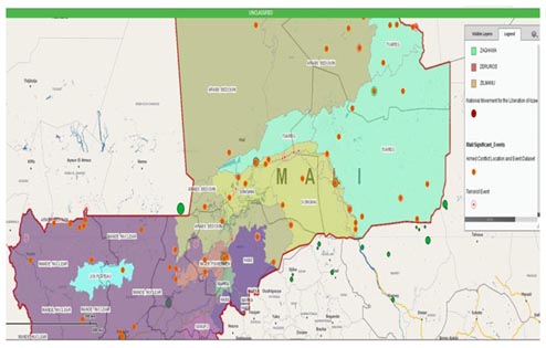
Figure 1: Locations of tribes overlaid with incidents of ethnic conflicts and terrorist acts.
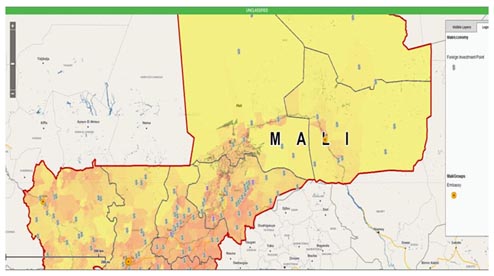
Figure 2: Overlay of population density [denoted by darker color], foreign investment [$] and embassy locations.
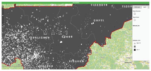
Figure 3: Night lights show locations of power based on the use of electricity at night.
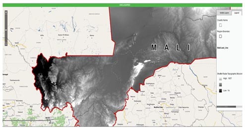
Figure 4: Shuttle Topograph Radar showing digital elevation models.)
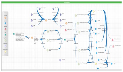
Figure 5: Link chart displaying the drivers of conflict/instability from the desk study of the Joint Sahel Project.
End Notes
i Johnson, Thomas H, and M. Chris Mason. "The Atlantic." October 1, 2008. http://www.theatlantic.com/magazine/archive/2008/10/all-counterinsurgency-is-local/306965/ (accessed 02 22, 2014), np.
[ii] This is not to suggest that regional and sociocultural expertise does not exist within the USG. The US Central Intelligence Agency maintains their World Factbook ( https://www.cia.gov/library/publications/the-world-factbook/ ) and the US Library of Congress maintains a collection of Country Studies (http://lcweb2.loc.gov/frd/cs/cshome.html ), each with valuable information for specific countries and regions that can contribute to gaining a better understanding of potential trouble areas. Furthermore, there are those country and regional experts employed by the USG who spend much of their lives working and living overseas and have a truly deep understanding of those areas.
[iii] Colonel Sarat, Paul S. "Trans Sahel Project Information Paper." February 12, 2014, np.
[iv] Colonel Sarat, Paul S. Email correspondence, March 04, 2014.
[v] White House. Fact Sheet: U.S. Security Sector Assistance Policy. Statement and Releases, Washington DC: Office of the Press Secretary, 2013. "National Security Strategy." Washington DC: White House, May 2010, np.
[vi] United States Agency for International Development. Conflict Assessment Framework V 2.0. Assessment Framework, Washington DC: USAID, 2012, np.
[vii] Colonel Sarat, Paul S. Email correspondence, March 04, 2014.
[viii] Ibid.
[ix] Swickard, Deane, interview by Ryan Satterwthaite. AFRICOM J2 Analyst (February 13, 2014).
[x] Arieff, Alexis. Crisis in Mali. Washington DC: Congressional Research Service, 2013, np.
[xi] The Associated Press. Africa: World Briefing. January 31, 2014. http://www.nytimes.com/2014/02/01/world/africa/aid-groups-warn-of-food-crisis-in-mali.html?_r=0, np.
[xii] Arieff, np.
[xiii] Arieff, np.
[xiv] Colonel Sarat, Paul S. Email correspondence, March 04, 2014.
[xv] Gezari, Vanessa, “When the Eggheads Went to War,” Newsweek.com August 16, 2013 http://mag.newsweek.com/2013/08/16/the-human-terrain-system-sought-to-transform-the-army-from-within.html (accessed March 07, 2014)
[xvi] Flynn, Michael T., Matt Pottinger, and Paul D. Batchelor. "Center for New American Security." CNA. January 1, 2010. http://www.cnas.org/files/documents/publications/AfghanIntel_Flynn_Jan2010_code507_voices.pdf (accessed February 12, 2014).
Bibliography
Arieff, Alexis. Crisis in Mali. Washington DC: Congressional Research Service, 2013.
Brook, Tom Vanden. "Army Times." Army Times. September 23, 2013. http://www.armytimes.com/article/20130923/NEWS/309230032/Army-leaders-warned-about-issues-Human-Terrain-System (accessed Feburary 09, 2014).
Colonel Sarat, Paul S. "Trans Sahel Project Information Paper." February 12, 2014.
Colonel Sarat, Paul S. Email correspondence, March 04, 2014.
Department of Defense. "Joint Operation Planning ." Military Manuel, 2011.
Flynn, Michael T., Matt Pottinger, and Paul D. Batchelor. "Center for New American Security." CNA. January 1, 2010. http://www.cnas.org/files/documents/publications/AfghanIntel_Flynn_Jan2010_code507_voices.pdf (accessed February 12, 2014).
Johnson, Thomas H, and M. Chris Mason. "The Atlantic." October 1, 2008. http://www.theatlantic.com/magazine/archive/2008/10/all-counterinsurgency-is-local/306965/ (accessed 02 22, 2014).
Kusiak, Pauline. "Military Review." November-December 2008. http://usacac.army.mil/CAC2/MilitaryReview/Archives/English/MilitaryReview_20081231_art011.pdf (accessed February 09, 2014).
Lamb, Christopher, James Douglas Orion, Michael C. Davies, and Theodore T. Pikulsky. "Joint Forces Quartely." July 2013. http://www.dtic.mil/doctrine/jfq/jfq-70.pdf (accessed February 09, 2014).
Merten, Steffen. Employing Data Fusion in Cultural Analysis and Counterinsurgency in Tribal Social Systems. Monterey: Center for Contemporary Conflict, 2009.
Rabasa, Angel, et al. From Insurgency to Stability; Volume II: Insights from Selected Case Studies. Santa Monica: RAND Corporation, 2011.
Swickard, Deane, interview by Ryan Satterwthaite. AFRICOM J2 Analyst (February 13, 2014).
The Associated Press. Africa: World Briefing. January 31, 2014. http://www.nytimes.com/2014/02/01/world/africa/aid-groups-warn-of-food-crisis-in-mali.html?_r=0.
United States Agency for International Development. Conflict Assessment Framework V 2.0. Assessment Framework, Washington DC: USAID, 2012.
Weinberger, Sharon. "Wired." October 07, 2007. http://www.wired.com/dangerroom/2007/08/in-short-what-a/ (accessed February 09, 2014).
White House. Fact Sheet: U.S. Security Sector Assistance Policy. Statement and Releases, Washington DC: Office of the Press Secretary, 2013.
"National Security Strategy." Washington DC: White House, May 2010.
About the Author(s)
Comments
I believe you make some great points; however, the use of CAF 2.0 is to gain a strategic understanding across the spectrum of agencies, organizations and policies of the OE. We are not espousing that we use intelligence in this forum, merely presenting information in a common construct that is easily digestible and sharable across organizations and even nations in order for everyone to understand a complex problem in the same way. This will lead to diving deeper and utilizing other such tools as the Stability Decision Support Framework for the operational and tactical levels to develop detailed plans to get after the problem. CAF 2.0 was decided on IOT reach a much wider audience for the purpose of understanding and information sharing, not intelligence sharing. There are, of course, other such mechanisms to accomplish intelligence sharing. CAF 2.0 does not require the complex information sharing agreements that intelligence does.
SERENGETI is definitely an encouraging development in the interagency effort to understand operational environments in ways we rarely bothered to attempt in the last 13 years. That organizations as vastly different as SOCOM and USAID are working together to this end is a mind-boggling feat of interagency coordination. But the difference in these organizations highlights one of the main problems in the use of CAF 2.0 as an assessment tool for Special Forces and Civil Affairs at echelons below the strategic. CAF 2.0 is a development tool in which the unit of analysis is a country. The DoD is not a development organization, and an assessment of a country is of little value to operators at the operational and tactical levels where generalizations don’t hold. And the use of CAF 2.0 also highlights a disappointing inability of DoD components to collaborate within the department before looking outside for solutions to military problems.
In their planning standardization course, the Marine Corps Tactics and Operations Group uses a civil considerations analysis framework (piloted at Twentynine Palms in collaboration with an Army Civil Affairs officer) called the Stability Decision Support Framework. Based on many of the same principles as CAF, this framework was created to directly serve commanders and staffs in their efforts to convert knowledge of the OE into understanding, and most importantly, into plans. This has been one of the primary difficulties for the military in planning operations that reflect understanding of the human terrain. What, exactly, do you do with the enormous volume of information about people? Without a way to operationalize it, that information quickly falls into the “nice to know” category while the S2 continues to churn out the “need to know” stuff.
Stability Decision Support Framework enables military forces to fit information and intelligence about the OE directly into the steps of the Marine Corps Planning Process and the Military Decision Making Process. Its primary goal is to enable military planners to do these six things:
1. Focus on mission-relevant civil considerations from the earliest phases of planning. For a planner in a time-constrained environment, knowing what you do not need to know is as important as what you do need to know. SOCOM units are not development organizations. They need to deal with the information about the OE that enables them to accomplish their missions. That is how military forces support development and other interagency initiatives.
2. Identify relevant population groups, their interests, centers of gravity, vulnerabilities, resiliencies, capabilities, and desired end states. Not every group of immigrant fishermen is relevant to the mission. Planners need to deal with the desired end states and capabilities of the groups that are relevant.
3. Anticipate and shape population most likely and most dangerous courses of action. For every environmental factor that can change – the weather, the enemy – planners do everything in their power to predict or anticipate these changes, since those changes can easily defeat the plan. With population groups, there has been no formal effort or process to do this until now.
4. Identify opportunities to reduce, or the risks of creating, instability that will influence the mission.
5. Identify root causes of instability.
6. Incorporate mission-relevant measures of effectiveness into planning before COA development so that missions and activities are specific and limited to achieving the desired effects.
There are many reasons outlined in the above article that our community of interest should stand up and cheer about the SERENGETI initiative. But there is at least an equal number of reasons that this initiative, and CAF 2.0, need to be refined to serve the ultimate ends of the warfighter. Stability Decision Support Framework is the tool that fills the wide gap between strategic and development concerns and operational and tactical “need to know” about the human terrain. Used together, these advances would be an incredibly powerful advance in the understanding, and operationalizing, of the complex information about human beings in the operating environment.